Monday, May 13, 2019

GLOBAL WARMING IN NORTHERN ARIZONA?


 Do you believe in global warming?

Increasingly violent and more frequent storms, floods, drought and fires are in the daily news.  These weather extremes are becoming the new normal and are attributed to global warming by the majority of scientists and governments throughout the world.  In spite of global opinion there are still people who do not believe in global warming.  Personally, I have witnessed the local climate getting warmer weather patterns changing in my lifetime.  

Photo taken towards Cameron on December 20th, 2016.  

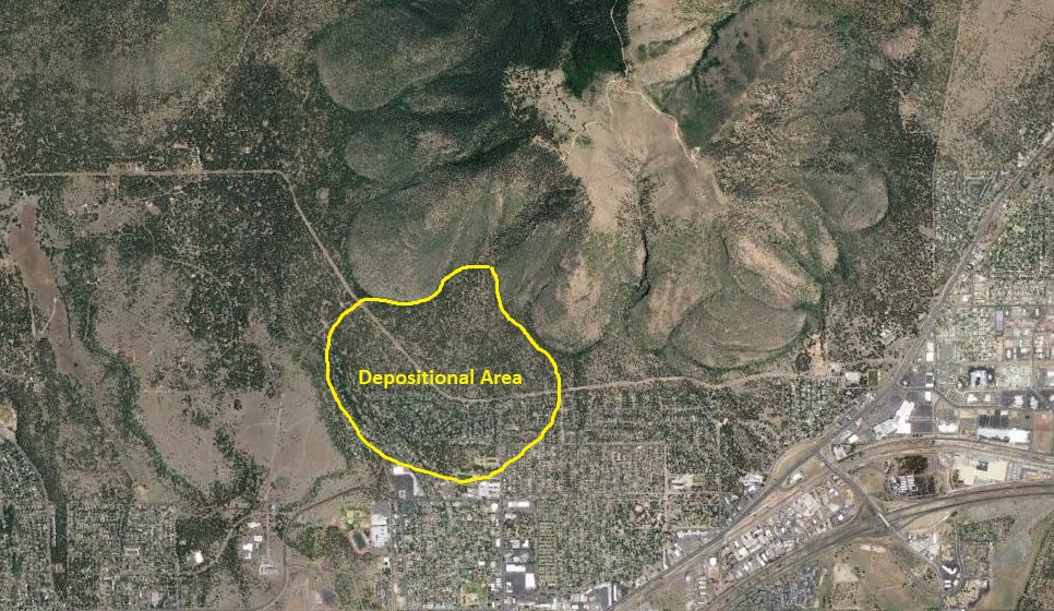
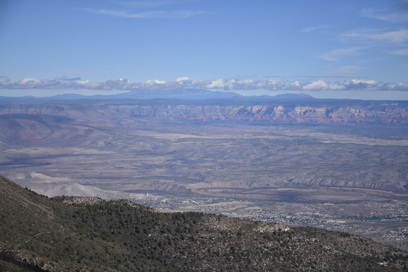
AIR POLLUTION:  Strawberry Crater looking north.  The first line of cliffs are 30 miles away.  Navajo Mountain on the Arizona/Utah border is 115 miles away and barely visible.  Today there is a permanent haze in the atmosphere caused by vehicles, high altitude jets, industry and dust.  Visibility is now considered to be 10 miles when a century ago it used to be 100.  The only time the sky is clear is for about 24 hours following a significant rain or snow storm which is the best time for landscape photography. 

TORNADOES:  Tornadoes are rare in Northern Arizona but they do occur usually in the flat grasslands east of Flagstaff.    There are exceptions.  

On October 24th, 1992 one tornado touched down at Sunset Crater and knocked over a few Ponderosa Pine trees and damaged others.

On October 10th, 2010 six tornadoes were spotted west of Flagstaff at Bellemont.  At least three of them touched down and left swaths of destruction for up to 34 miles through the Coconino National Forest.   One EF3 tornado passed through Bellemont which derailed a train, destroyed the entire RV inventory of the Camping World dealership and damaged 30 homes.  That day 22 tornado warnings were issued by the National Weather Service for locations surrounding Flagstaff. 

Tens of thousands of trees were destroyed.

Twisted Ponderosa Pine tree.

30 homes  sustained significant damage. 

28 box cars derailed and damaged.

Camping World RV Dealership

Utility poles snapped off.

DROUGHT:   Northern Arizona has been in continual drought since 2002.  In some years significant amounts of rain or snow fell but overall precipitation was still below average.  The worst years were:
2002-2004, 2006-2007, 2010, 2012-2015 and 2018.
Drought is particularly devastating  because it carries such destructive secondary consequences.

BARK BEETLE:   The Bark Beetle outbreak that started in 2002 still continues today.  According to the United States Department of Agriculture between 2 and 3 percent of the  trees in Coconino National Forest have perished with up to 90 percent at localized sites. 

Bark Beetle Ponderosa Pine tree kill.

The only thing that can stop the bark beetle attack is rain and snow.  If the trees contain enough moisture  pitch will  drive the beetles out of their borrows underneath the bark.  This would require repeated years of above average precipitation which there is little hope for.

FIRE:   Fire is the most frequent hazard to occur in Coconino National Forest.  Since 1977 six mayor fires and dozens of  smaller ones burned areas of the forest.  Drought doesn't light fires but make them easier to start and to keep burning.  

1977 Radio Fire - Mt. Elden - 4,600 acres

1996 Hochderffer Hills Fire - NW of San Francisco Peaks - 16,680 acres

2000 Pumpkin Fire - Kendrick Peak - 14,760 acres

2006 Brins Mesa Fire - Wilson Mt to Slide Rock - 4,317 acres

2010 Schultz Fire - East side San Francisco Mountain - 15,075 acres

2014 Slide Fire - in Oak Creek Canyon -  21,000 acres

Slide Fire

The Slide Fire had progressed into Sterling Canyon just seven miles from our house and headed directly for us.  We were told to prepare to evacuate.  Two days later the fire was stopped at a fire-break six miles away. 

There was a 19 year separation between the 1977 Radio and 1996 Hochderffer fires suggesting conditions were wetter during the 70's and 80's.  I was actively hiking and backpacking in those decades and I don't recall any mention of drought during those years.      

1977 Radio Fire - Mt Elden............................................................... 4,600 acres
1996 Hochderffer Hills Fire - NW of San Francisco Peaks................16680 acres
2000 Pumpkin Fire - Kendrick Peak..................................................14760 acres
2006 Brins Mesa Fire - Wilson Mt and lower Oak Creek Canyon......4317 acres
2010 Schultz Fire - San Francisco Mountain.....................................15075 acres
2014 Slide fire - Upper Oak Creek Canyon and West Fork...............21000 acres
                                                                                         TOTAL......76,432 acres
                                                                                                            (120 sq. miles)

FLOODS:   There is one advantage to being in a drought; it means there is less chance of a flood.  Oak Creek has flooded many times almost always due to rain falling on a snow pack in the mountains.  Since 1993 the annual floods have generally gotten smaller and less frequent.  The largest flood in recorded history was in 1993 which reached a flow of 23,000 cubic feet per second (cfs).  There have been dozens of high water events over the decades but the five largest Oak Creek floods since 1982 were:

February,  1993     23,000 cfs
March,      1995     17,000 cfs
February,  2005     19,000 cfs
February,  2008     10,000 cfs
February,  2019     13,000 cfs 

Slide Rock, most likely 1993.

Rainbow Trout Farm below Indian Gardens,  2019

Lower Oak Creek,  2019


RAIN:  For as long as I can remember May and June where the two driest months of the year.  Then in 2017 significant precipitation fell during those months.  It wasn't heavy rains, just numerous small storms.  It had the odd effect of triggering all the Sycamore trees along Oak Creek to whither and drop their leaves like it was fall.  Over the rest of the summer the leaves then grew back again.

I contacted the Coconino National Forest botanist and he was unaware of it.  I later learned it was from a fungus that had formed on the leaves because of the timing of the rains.  This year we've had more than an inch of rain in May and the Sycamore trees are dropping their leaves, not as fast as in 2017 but it's happening again.    

SNOW:   In the 1980's when my children were young we took them out on Halloween for trick-or-treating.  Every year we would bundle them up because invariably there were a few inches of snow on the ground that had fallen in the last half of October.  That is not the case today.  The first measurable snowfall now falls in November if even then.

Also in the 1970's and 80's I was a cross-country and downhill skier.  The snow is not as reliable for these sports today. The ten year snowfall average in Flagstaff in 1980 was 110" per season.  By the year 2000 it had fallen to 90" and by the end of this decade it will be closer to 80".  (1980 and 2000 averages ascertained from National Oceanic and Atmospheric Administration data.)  
  
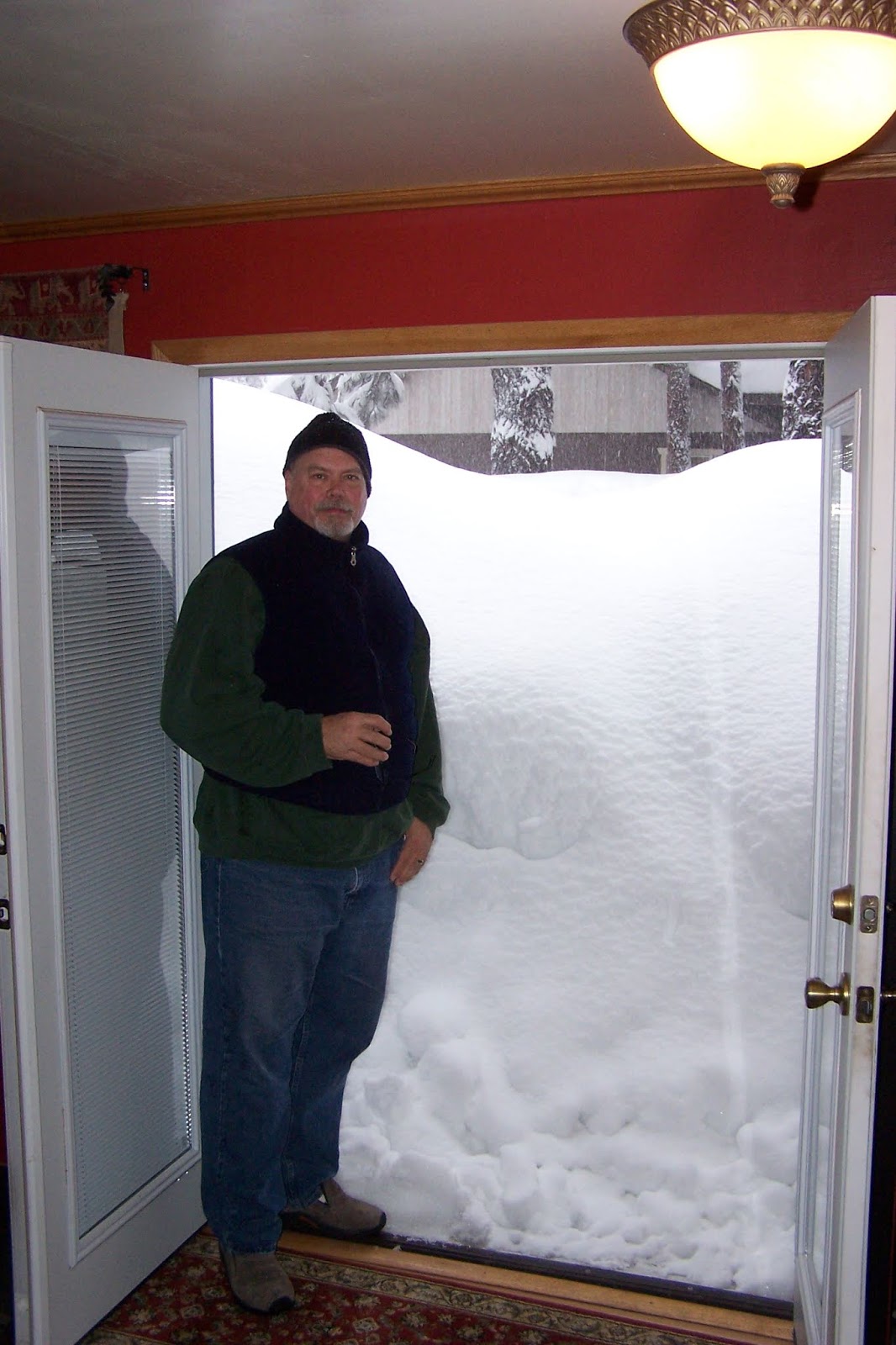
In January 60" of snow fell on our house in two days.

One of the exceptional storms.

We occasional have very heavy storms but they are the exception and the average precipitation is getting less. So is global warming real?  I definitely believe it is.

Sunday, May 5, 2019

FOSSIL ANIMAL BURROWS


Last week I was driving up an unnamed cinder cone near O'Leary Peak north of Flagstaff.  A road cut in the hill had exposed a number of fossil animal burrows.  They stood out against the black cinders because they had filled with white material.  

Trace fossil of an animal burrow.
A trace fossil is the evidence or imprint of an animal but not the animal itself.

I took a piece of a borrow that had fallen out of the hill home and looked at it with a 10x loupe. It was a conglomerate of pyroclastic (fire broken) rocks and small cinders surrounded by a white matrix. I immersed a piece of it in vinegar. It started to fizz and within an hour the matrix had pretty much disintegrated into a brown ooze leaving just rock pebbles and cinders behind. This indicated the matrix to be calcium carbonate (limestone.)

When I collected this trace fossil burrow it was a single piece
but it was very fragile and broke in two on the drive home.

Ash funneled down into an animal burrow.

At least three separate cinder eruptions (1-3) took place in a relatively short period of time.  (There is no soil accumulation between layers 1, 2 or 3.)  Layer 2 was preceded by a small ash eruption visible as the white seam just above the number 1.  The ash boulders at the bottom fell from the top pyroclastic layer as they were undercut by the faster eroding cinders beneath them.   

Layer A of soil accumulated.

As the volcano lay dormant for many years about 6 inches of eolian  red/orange soil (layer A) accumulated on top of the black cinders.  Grasses and small plants started to grow then critters moved in and dug the burrows down through the soil and into the cinder layers below.

Where did the limestone come from?  

Underneath all the volcanoes and lava flows around Flagstaff is a 350' thick layer of the Kaibab Limestone.   All volcanoes and vents must penetrate through this limestone to reach the surface.  Since this volcano had been dormant a hard cap had formed at the base of the volcano and sealed the vent.  As the volcano reawakened pressure built up under the plug until it violently exploded enlarging the original vent and pulverizing more of the limestone.  It was a short lived pyroclastic eruption as there is only a thin layer of ash 3 or 4 inches thick on top of soil A. 


After the limestone rich ash cloud descended the volcano erupted a layer several feet thick of cobble size cinders before it died.  Over the following millennium soil blew in and covered the cobbles (layer B), plants returned and so did the burrowing creatures.


Monday, April 22, 2019

MT. ELDEN LANDSLIDE

Mt Elden is a volcano looming over all of east Flagstaff.  It is nearly 2,400 feet tall and has very steep slopes that look like long overlapping tongues.  The steepness is due to dacite lava which is thick and sticky and flows like taffy.

Mt. Elden Google Earth image.

The volcanic dome is also a laccolith which is magma that is intruded between layers of rock strata which are consequently uplifted like a blister. As the blister enlarges it fractures at the top and lava erupts at the surface flowing over and around the uplifted strata.


The Mt. Elden laccolith intruded under the red Moenkopi sandstone which is well exposed at the Route 66 road cut just east of the China Star Restaurant. The dacite lava dome became so steep that the layer of sedimentary rock slid off the side of the lava dome in a massive landslide into the area where the Shadow Mountain neighborhood is now and as far as Linda Vista Drive and Jamison Boulevard.


There may have been a trigger that started the landslide besides just the steep gradient of the laccolith.  The photo below shows the escarpment left behind after the landslide occurred.


At the apex of the escarpment is a rock formation known as Devil's Throne.  This rock and several smaller extrusions were pushed up along a linear fracture in the laccolith just above the top edge of the Moenkopi sandstone slab.  Their placement and enlargement may have provided the push that sent the side of the mountain down.  Not to worry though, all this happened a few hundred thousand years ago.
  

I'M BACK


I have not written any posts for three years.  I haven't had (or made) time for exploring the countryside or taking photos.  I had a knee replacement, my wife and I both retired, we sold our house in Flagstaff and remodeled an old house in Sedona that we now live in.  I've been busy but now I'm back.

June, 2017

May, 2019

COSMOGENIC DATING


Since the 1990's scientists have been able to date surface rocks by using the cosmic rays emitted by stars. Cosmic rays from ancient exploding supernovas bombard the surface of the Earth constantly. When those rays strike a rock on the surface they shatter the elements within the rock minerals. Magnesium, for example, decays into a particular form of helium. By determining the ration of helium to magnesium the approximate age that rock has been exposed on the surface can be calculated. 

This method can be used to date surface rocks 10 to 30,000,000 years old and can tell when a rock fall occurred, a glacier melted or a volcano erupted. 

Radiometric dating is similar but is used to determine when a rock formed based on the decay or half-life of heavier radioactive elements into lighter elements, such as uranium into lead. Radiometric dating is used for revealing the age of rocks as old as our solar system.

Strawberry Crater - 55,000 years old.

SP Crater - 60,000 years old.


Monday, April 15, 2019

COCONINO NATIONAL FOREST TANKS

Anyone who has driven the dirt roads through Coconino National Forest have seen the water tanks as they are called on maps and occasional sign posts.  They are just small ponds where animals can get a drink during the dry season.  They are all located in low areas where they collect snow melt and runoff from the summer monsoon rains.  Many are located around seasonal water seeps or springs. 


Blue Grade Tank in Rarick Canyon near Beaver Creek

Spring fed Locket Meadow Tank on San Francisco Mountain

Committee Tank, Schnebly Hill at the head of Jack's Canyon

There are literally hundreds of them throughout the national forest and a dirt road leads to every one of them.  It seems there are far more tanks than what are needed to water just the local wildlife so I looked into it.

Most of the tanks were dug in 1916 using horse drawn metal scoops called Fresno Scrapers or dirt scoops.  The federal government financed the project to encourage ranchers to raise cattle on national forest land.  The government would then buy the livestock to feed the US troops fighting World War I in Europe.  Originally dug to support the war effort they are maintained today by the National Forest Service to support wildlife and for grazing cattle and sheep on leased land.

Invented in 1883 by James Porteous in Fresno, California.

Sedona Heritage Museum

Fresno Dirt Scoop in use.

Not all ponds in the forest are tanks.  Some are springs where regional aquifers seep to the surface. How to tell the difference?  All tanks have C shaped earthen berms on the down hill side where sinks will not.  Another clue is tanks generally have opaque, brown water where natural ponds or sinks will be cleaner and may have plants growing in them.  Many of the tanks and sinks are seasonal and will dry up in drought years.

Saginaw Sink
November, 2012

Quarry Sink
July, 2015

Rocky Hole Tank (actually a sink)
November, 2012

Friday, April 12, 2019

PILLOW LAVA


Pillow Lava is a bulbous shaped rock that forms when a volcanic eruption occurs under water or when hot lava flows into water.  This is currently happening in Hawaii.  Arizona being a land-locked state for the last 1.75 billion years and 350 miles from the Pacific Ocean one wouldn't expect to find such rocks, but I have located four exposures in Central Arizona thus far.   

On interstate highway I-17 from Phoenix to Flagstaff north of Black Canyon City is one location.  A road cut in the north-bound lane at mile marker 249 is a hill of pillow lava between 8 and 16 million years old.  The Pacific ocean was hundreds of miles to the west at the time so this must of occurred as lava flowed into a lake.

I-17 is heavily traveled so stopping here can be an unnerving experience.

The bulbous nature of the rock is obvious.

One canyon SE of Jerome is Mescal Gulch where there is another exposure of pillow lava.  A marine volcano erupted about 1.75 billion years ago, was buried by later lava flows then covered with sediments.  The pillow lava bed was heated and compressed and mildly metamorphized.  Around 8 million years ago the land was lifted along the Verde Fault line creating the Black Hills overlooking Verde Valley.

Mescal Gulch
Jerome is 3 miles to the right and the pillow lava exposure is just out of the photo on the left.

The pillow lava was metamorphosed so the bulbs are
compressed together.

Lower Gulch Road and FS Road 413

Forest Service Road 413 starts from the Lower Gulch Road in Jerome. It is a 3.3 mile walk to the pillow lava, or from Cottonwood it is a 9.5 mile drive.  A 4 wheel drive high clearance vehicle is necessary.  Take Mingus Avenue past the airport.  The pavement ends and turns to dirt.  In less than a mile is a big dirt parking lot.  The road leaving the parking lot is Forest Service Road 493 although there is no sign.

The big dirt parking lot

In about a mile the road splits.  Take the 
road to the right which is FS Rd 493.

A rough section in the road.

In about 6 miles FS Rd 493 joins up with FS Rd 413.  
Turn right to go to the pillow lava.  If you turn left 
you can go all the way to the top of Mingus Mountain.

Mingus Mountain

Verde Valley

The best exposure of pillow lava I have found is also the easiest one to get to.  Just 2.7 miles west of interstate I-17 on highway SR-169 is a road cut 20 feet high and 900 feet long through a hill of basaltic pillow lava.  It flowed into a lake between 8 and 16 million years ago.

There is little traffic and a wide shoulder to pull to the side.

The bulbs are clearly distinct.

The lava is extruded into water so it cools quickly in layers from the outside inward.

This makes layers like those of an onion that peal off in thin flakes as they weather and erode.

Recently I came across another site I believe to be pillow lava although it's an unusual type that I have not seen or read about before.  It is basalt, bluish in color and made up of indistinct bulbs of cobble sized gravel.  The mass is only partially welded together so it seems the lava was relatively cold when it erupted.  Though I wonder why it was gravel and why did it erupt at all if it was already solidified?  Is it even pillow lava?   

It is located on Forest Service Road 689 which runs parallel to Interstate I-17 between Beaver Creek Road and Stoneman Lake Road.   On topographical maps it is identified as 'Blue Grade' through this part of the canyon for obvious reasons.

The Blue Grade
The road cut exposed the blue gravel lava.  It was mined and used as fill and the base layer in construction of the road.    
    
The quarry next to the road.

The pillows are indistinct but still visible.

The best preserved pillow

Years ago I read a geologic report there is an exposure of pillow lava in Black Canyon somewhere in the ophiolite sequence (oceanic crust and mantle) located there.  It did not say where.  It is a big area and as yet I have not been able to find them.  There are many black dikes in Turkey Creek Canyon and I would think pillow lava would be found at the top of some uneroded hill.  It's very rugged country and inaccessible to me.

Eroded dikes