The San Francisco Volcanic Field is an area of volcanism that stretches from the edge of the Colorado Plateau about 10 miles west of Williams, Arizona for 60 miles to the east of Flagstaff. It is generally 30 miles wide and approximately 1,800 square miles. Within it lie over 600 volcanic vents, countless lava flows and the San Francisco Peaks, the highest point in the state at 12,633 feet and a stratovolcano.
Faults are common in areas of volcanism for two reasons. Preexisting faults can provide conduits for magma to migrate through the lithosphere to the surface. Also faults can be caused by a magma chamber rising up from the asthenosphere that forces the crust above it to bulge up and crack. Since magma chambers can inflate and deflate like a balloon the faults above can open and close and move up or down.
There are six major faults that intersect with the San Francisco Volcanic Field. North of Flagstaff are the Mesa Butte fault, the SP Graben and the Doney Mountain Fault. South of Flagstaff are the Lake Mary Fault Zone and the Oak Creek Fault. To the west is the Bill Williams Fault. No doubt there are other faults but these are the most visible either on the ground or from space. Three faults are visible in the Google Earth satellite image below of an area north of Flagstaff; the Mesa Butte fault, the SP Graben and the Doney Mountain Fault.
MESA BUTTE & BILL WILLIAMS FAULT
 |
| Google Earth image. |
The Mesa Butte Fault, despite the contradictory name, is impressive. It is a wide, deep trench visible from the space shuttle at a Low Earth Orbit of 125 miles. It defines the eastern edge of the Gray Mountain Mesa, then cuts through the mesa as a trench one-quarter mile wide and 600 feet deep as it heads southwest for 28 miles. It disappears into the San Francisco Volcanic Field at highway SR 180 between Slate and Red Mountain where it is filled then buried by numerous lava flows.
 |
| Eastern face of the Mesa Butte Fault escarpment. |
 |
| 4WD road Indian Route 6150 up the Mesa Butte Fault escarpment. |
 |
| The Mesa Butte Fault trench looking south. |
If you draw a straight line between Mesa Butte Fault and extend it southwest to the Bill Williams Fault it will pass directly under Kendrick and Sitgreaves Mountain near Williams. Both are significant volcanic domes of high silica lava. It is suggested by some geologists the Bill Williams Fault is an extension of the Mesa Butte Fault and they are one-and-the-same.
 |
| Arizona Geological Survey Map image. Fault are red lines. |
Obviously the Mesa Butte Fault named after the Mesa Butte cinder cone was a conduit for magma to reach the surface. The Bill Williams Fault is not visible by satellite and is much harder to follow. It too has been covered by lava flows and hidden under vegetation and a Ponderosa Pine tree forest.
SP GRABEN
SP Graben is named for SP (Shit Pot) Crater nearby. It was thus named in reference to the rim of the cinder cone being absolutely covered by a layer of lava droppings that looked like a filthy toilet. It is, I've been up there.
 |
| SP Crater inner rim |
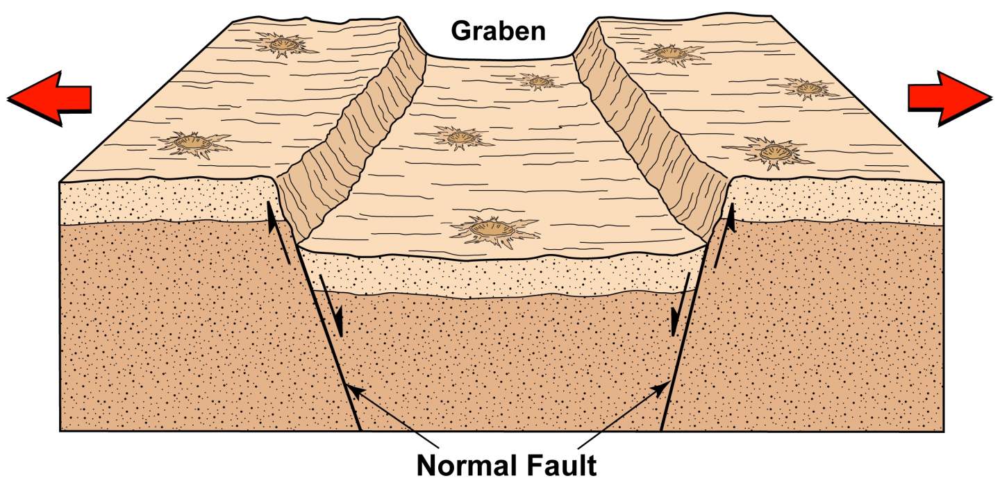
A graben is a geological term meaning two parallel faults with a down dropped strip of land between them.
 |
A graben forms when the land is stretched apart.
If of significant width and length it may be referred to as a rift valley. |
 |
| Google Earth image. |
SP Crater is a world famous cinder cone in the geological community. It's near symmetrical shape and well defined features make it the classical definition of a cinder volcano. The distinctive lava flow and graben made it a choice location for training the Apollo astronauts in the 1960's for the moon landings.
The graben does not appear to be a branch of or connected to the Mesa Butte Fault. Overall the graben points directly at the San Francisco Peaks. It is about 8 miles long, 800 feet wide and 100 feet deep before its southern end is buried by the lava flows of the San Francisco Volcanic Field.
SP Crater is not on the graben but 3/4 mile to the east of it, however its lava flow pours into it at two locations. This suggests to me an intruding magma chamber expanded the earth and the graben formed before SP Crater erupted.
 |
| Two lobes of the SP lava flow drain into the graben. |
 |
| Oblique view of the lava lobes and graben. |
 |
| East escarpment wall of the graben. |
DONEY MOUNTAIN FAULT
Doney Mountain Fault is north of Flagstaff partly inside the boundaries of the Wupatki National Monument. It is not remarkable looking but it may have had a big affect on the San Francisco Volcanic Field.
|
| Google Earth image. |
It is named for Doney Mountain, a series of small cinder cones formed by a fissure eruption at the south end of the visible fault. At that point is where the fault disappears under the lava flows and volcanoes of the San Francisco Volcanic Field.
 |
| Google Earth Image |
 |
| Arizona Geological Survey internet image. |
 |
| Doney Fault escarpment north of the cinder cones. |
 |
| Limestone escarpment face. |
 |
Looking north at the Doney Mountain cinder cones.
Photo copied from the internet. |
There is no reason to believe the fault just ends at Doney Mountain cinder cones, it must continue on to the southwest under the lava flows. Its directional trend takes it close to or under Strawberry Crater, O'Leary Peak and towards the Dry Lake Hills or Mount Elden.
 |
| Strawberry Crater |
 |
| O'Leary Peak |
 |
| Mt. Elden (far left) & San Francisco Peaks (center). |
Moving south of Flagstaff the Oak Creek Fault and the Lake Mary Fault Zone are outside of the San Francisco Volcanic Field. However, the north end of both of these faults migrate into the field and under the San Francisco/Mt. Elden volcanic complex once they cross the I-40 Interstate Highway.
The faults are difficult to see from above because of the dense forest canopy so I drew them in on the Google Earth image below.
 |
| Google Earth image |
 |
| Arizona Geological Survey Map |
The Lake Mary Fault is not one continuous fracture but a series of shorter segments orientated in the same direction. It is comprised of the Lake Mary Fault, the Ashurst Run Fault and the Mormon Lake Fault which is why it is referred to as a fault zone. One southern segment runs just east of Mormon Lake and the viewpoint overlooking the lake sits on top of the escarpment. Other segments define the edge of Ashurst Lake, Anderson Mesa and Lake Mary.
 |
| Looking south along the Mormon Lake Fault escarpment. |
A second fault runs parallel on the opposite side of Lake Mary which means Lake Mary lies in a graben. The graben and segmentation of the fault suggests to me stretching of the earth and possible inflation by magma.
 |
| Lake Mary graben. |
This fault zone has a vertical displacement of up to 300 feet and is about 27 miles long from East Flagstaff to past Mormon Lake where it disappears under lava flows. It is considered to pose the most likely earthquake threat to Flagstaff and has been active off and on since 1892.
The Oak Creek Fault is a different beast entirely. It is one continuous fault with a few secondary branches. It runs from the San Francisco Peaks for 36 miles south to just past the Village of Oak Creek in the Verde Valley. It is a normal fault with a vertical displacement of 1,000 feet between the east and west elevations. It is not known to have slipped in human history but there were noticeable tremors at depth on it in 2014 and 2015.
The Oak Creek Fault is old and deep. It predates the San Francisco Volcanic Field by more than 1.5 billion years. It has certainly served as a conduit for magma rising from the earth's asthenosphere. There are at least 5 volcanoes along its path from south to north; Wilson Mountain, Woody Mountain, Naval Observatory, A1 Mountain and the San Francisco Peaks.
It is obvious that volcanoes are associated with all of the major faults in the San Francisco Volcanic Field which brings me to my purpose in pointing out these faults. Recently I was browsing the internet looking at geologic photos then I came across this one of quartz veins in a bedrock. It is an area probably just a few square feet.
The moment I saw it I thought of the San Francisco Volcanic Field and its crisscrossing faults. I started wondering what would the San Francisco Volcanic Field look like millions of years in the future if were eroded into a flat plane? I think it would look similar to this except scaled up to many square miles with thick, black basalt dikes through red sedimentary rocks.
That exact scenario has happened at the Shiprock volcano just 200 miles away in New Mexico. Shiprock is the last remaining remnant of a volcano that erupted 27 million years ago. Since then the surface volcano has completely eroded away as well as 3,000 feet of sedimentary rock surrounding the monolith. Radiating out it are three faults called dikes that were the conduits that supplied basaltic magma to the volcano.
 |
| Shiprock photo from the internet. |
 |
| Google Earth image. Three dikes. |
 |
| Dike # 1 photo from the internet. |
If this were to occur at the San Francisco Volcanic Field there would be six monoliths stabbing at the sky. They would be the remnants of Bill Williams Mountain, Sitgraves Mountain, Kendrick Peak, Slate Mountain, O'Leary Peak and the San Francisco Peaks, the crown jewel of them all. There would be a maze of long black veins running between them through fractured sedimentary bedrock. I think that would be quite a sight and look very much like this photo of veins in a rock.


