A thick layer of limestone lies underneath the volcanoes and lava flows known to geologists as the San Francisco Volcanic Field. Tectonic forces have created faults and earth cracks throughout the Flagstaff area. In addition, acidic rain, which all rain is because of volcanic gasses and our industrial society slowly dissolves cavities in the limestone.
The Bottomless Pits
The Rio de Flag runs into the pit - circa 1906
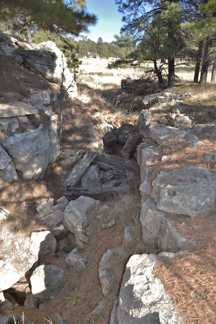
The same channel in 2012.
The Bottomless Pits opening - circa 1913
Unfortunately dirt, rock assorted trash hide the opening in 2012.
It is not a sinkhole but a crack in the earth along a fault. It may be a branch of the Anderson Mesa Fault or certainly connected to it. A seismic study performed in 1997 shows the pit leads to a labyrinth of cracks and chambers 2,000 feet deep. In 1991 four teenagers climbed down into the hole and found a system of old rope ladders. They explored part of the cavern but two of the boys had to be rescued when they could not climb back out. After that the city plugged the entrance with rocks, dirt and debris which was flushed down when it flooded again in 1993. In 2014 the pit was surrounded by a barbed wire fence and closed to the public.
An crack in the earth next to the pit.
The Timberline Drain
After a heavy rain in the summer of 2010, I was playing golf at the Timberline golf course. A drainage ditch that crossed the course was full of water when it suddenly emptied down a hole in the ground. I found this to be a rather disturbing occurrence and suggested to the manager they put a fence around it. He told me it was nothing to worry about, they regularly filled the hole with grass clippings and leaves.
I'm pointing at the hole in the ditch by the 3rd green.
For years the hole has been filled repeatedly with leaves
and grass clippings from the golf course to plug it up.
and grass clippings from the golf course to plug it up.
It is probably another opening to the Bottomless Pits which is only a quarter-of-a-mile away. As of 2016 it still doesn't have a fence around it and I wouldn't suggest walking on it looking for an errant ball. I christened it the Timberline Drain.
The Twin Tanks Drain
South of Flagstaff and east of Mountainaire I found a disappearing stream very near the head of Priest Draw. I had driven by it many times and hadn't recognize it for what it was, then I noticed it while exploring on Google Earth. I knew the direction of flow and saw it disappeared into some trees and didn't emerge. I drove there to check it out.
Although the stream is dry in this Google Earth image, it is still easily visible.
What I found there were five shallow depressions in the ground ten to twenty feet across. They were in a line within a natural trench orientated to the southwest toward a stand of trees. Near the trees the dry stream bed intersected the trench. Under the trees was a limestone outcrop with a wide crack through it where the stream emptied into it. It is a vertical displacement fault with a SW by NE strike. I wondered if it intersects the Anderson Mesa Fault just three miles away, and could it be part of the same fault crack that is at the Bottomless Pits, nine miles to the north?
The Twin Tanks Drain
The source of the stream, when running, is two shallow sinkholes known as Twin Tanks one mile to the south; one is dry and the other has a dirt berm pushed up around so it will hold water for wildlife and livestock.
The Coulter Park Drain
Eleven miles south of Flagstaff and east of Howard Mountain is Coulter Park, a grassy meadow a few hundred feet wide and a mile-and-a-quarter long. Every spring snow melt drains from the park and flows in a stream down a shallow canyon. I followed the stream for a mile where it abruptly ended at a hole in the earth.
The Coulter Park Drain.
The hole looks large enough to climb down into but it is blocked by huge lava boulders.
The Horse Trap Sink and Drain
Another disappearing stream I found drains the Horse Trap Sink out Woody Mountain Road. It is on Forest Service Road 530A and only 100 yards from the Horse Trap Sink. The stream bed is short and unremarkable where it disappears into some lava boulders. It is entirely possible that the water pours through the roof of a lava tube or it just passes through cracks in the basalt into a limestone cave beneath it.
The stream runs across a grassy field and under the barbed wire fence to a pile of basaltic
boulders right next to the road. Horse Trap Sink is in the extreme right of the photo.
boulders right next to the road. Horse Trap Sink is in the extreme right of the photo.
Lava boulders and dirt plug the opening to the Horse Trap Sink Drain.
It obviously hasn't run recently.


Mark Thomas - Geology: Cracks, Holes And Disappearing Streams >>>>> Download Now
ReplyDelete>>>>> Download Full
Mark Thomas - Geology: Cracks, Holes And Disappearing Streams >>>>> Download LINK
>>>>> Download Now
Mark Thomas - Geology: Cracks, Holes And Disappearing Streams >>>>> Download Full
>>>>> Download LINK
Mark Thomas - Geology: Cracks, Holes And Disappearing Streams >>>>> Download Now
ReplyDelete>>>>> Download Full
Mark Thomas - Geology: Cracks, Holes And Disappearing Streams >>>>> Download LINK
>>>>> Download Now
Mark Thomas - Geology: Cracks, Holes And Disappearing Streams >>>>> Download Full
>>>>> Download LINK nQ